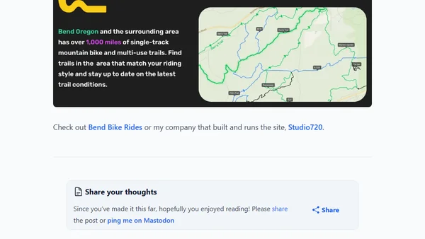
Blogs
A blog covering data visualization, spatial analysis in R, election mapping, and social science data, with a focus on technical methods and tools.
A technical analysis of NYC mayoral election results using R, spatial data, and GIS techniques to create maps visualizing precinct-level voting patterns.
A technical tutorial on using R and the sf package to adjust map boundaries, specifically addressing the Crimea region's political representation in geographic data.
A technical tutorial on creating interactive world maps with USAID foreign aid data using Observable Plot and JavaScript.
Overview of Overture Maps Foundation's updated global, open geospatial datasets, their partners, and data refresh strategy.
A technical guide comparing spatial patterns in continuous raster data for overlapping regions using R, focusing on NDVI data analysis.
A technical guide on processing Overture Maps' global land cover dataset, focusing on extracting and analyzing Australia's data using DuckDB and QGIS.
Using R and geospatial data to calculate and compare the proportion of coastline to land borders for US states, with Rhode Island as a key example.
A technical walkthrough of preparing and analyzing the global Open Charge Map dataset for EV charging points using DuckDB and Python.
A technical guide on creating a custom Tokyo walking tour map using GIS tools, QGIS, Python, and OpenStreetMap data.
An analysis of Overture Maps Foundation's open geospatial datasets, their creation process, and a technical guide for working with the data using Python and DuckDB.
A review of Esri's 'Imagery in Action' MOOC, covering satellite imagery analysis, drone mapping, and predictive modeling with ArcGIS tools.
A review of Esri's Spatial Data Science MOOC, covering the history of GIS, ArcGIS Pro's features, and the author's training experience.
A technical walkthrough of scraping and visualizing global airline passenger route data using Python, DuckDB, and QGIS.
A technical tutorial on using R to analyze and visualize personal Google Location History data, using a 5,000-mile road trip as a case study.
A technical tutorial on using R and OpenStreetMap to create custom, data-driven maps for planning and visualizing a complex road trip route.
A tutorial on creating maps of Tolkien's Middle Earth using R, the {sf} package, and {ggplot2} for GIS data visualization.
A technical overview of DuckDB's new Spatial extension, detailing its geospatial file format support, core dependencies, and setup process.
A technical guide on extracting Monaco's road network from OpenStreetMap, importing it into PostgreSQL/PostGIS, and rendering it with a tile server.
A technical guide on calculating landscape metrics in R using spatial data and buffers around sampling points for ecological analysis.