Visualization
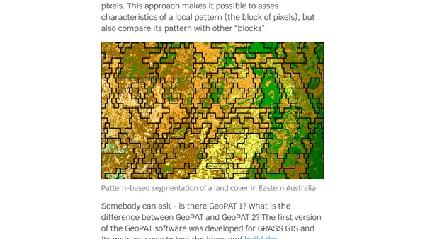
A blog archive listing numerous data visualization projects, tutorials, and analyses, primarily focused on demographic, social, and public data.
Exploring the GM-SEUS dataset of US solar farms using GIS tools like QGIS and DuckDB for spatial data analysis.
Exploring Planet Labs' open hyperspectral satellite imagery data, including setup and analysis using Python, GDAL, and DuckDB.
Using R and geospatial data to calculate and compare the proportion of coastline to land borders for US states, with Rhode Island as a key example.
Explains how to use the spatial kinetic Ising model in R to simulate changes in binary spatial patterns, like land cover.
Using Azure Data Explorer's geo_info_from_ip_address function to locate a hacker by mapping IP addresses on a scatter plot map.
A technical guide on using geospatial data and cloud computing to optimize 5G network deployment, considering environmental factors like trees.
A technical guide on clustering similar spatial patterns from raster data using R, focusing on land cover and landform analysis in Africa.
A technical tutorial on using GeoPAT2 and R to calculate Shannon entropy for land cover patterns in local landscapes.
Introduces the 'sabre' R package for quantitatively comparing two categorical maps or regionalizations to measure spatial similarity.
Final post in the GeoPAT 2 series, exploring advanced pattern-based spatial analysis methods and integration into custom workflows.
Explains pattern-based regionalization using GeoPAT 2 software to segment landscapes into homogeneous regions based on spatial patterns.
Explains how to use GeoPAT 2 software to measure changes in landscape patterns over time using spatial analysis techniques.
A technical tutorial on using GeoPAT 2 software to find geographically similar landscapes through pattern-based spatial analysis.
Introduces GeoPAT 2, an open-source software for pattern-based spatial and temporal analysis of categorical maps like land cover.