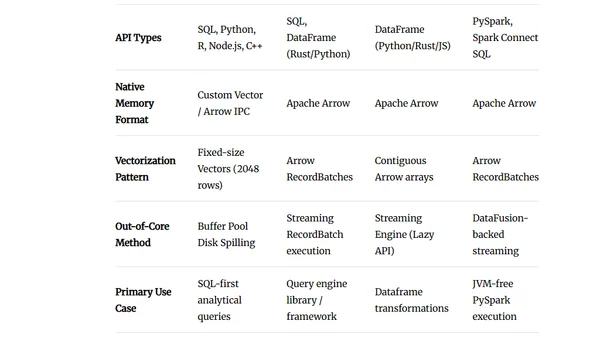
Microsoft's 2026 Global ML Building Footprints
Analysis of Microsoft's 2026 Global ML Building Footprints dataset, including technical setup and data exploration using DuckDB and QGIS.
Analyzing All The Places' open-source location data project, detailing the technical setup and process for downloading and examining millions of brand locations.
A technical analysis and comparison of various administrative boundary datasets, including OpenStreetMap, using Python, DuckDB, and QGIS.
Analyzing Business Insider's dataset on US data center locations, ownership, and resource consumption using Python, DuckDB, and QGIS.
A technical walkthrough of converting the US Wind Turbine Database to Parquet format and analyzing it using tools like GDAL, DuckDB, and QGIS.
A guide on importing Java Flight Recorder (JFR) profiling data into DuckDB for analysis using SQL queries.
Exploring the GM-SEUS dataset of US solar farms using GIS tools like QGIS and DuckDB for spatial data analysis.
A technical exploration of the ICMM's global mining dataset, detailing the setup, tools, and process for data analysis using Python, DuckDB, and QGIS.
An analysis of Statistics Canada's Open Database of Buildings (ODB) dataset, covering data processing, tools used, and technical setup.
A tutorial on using Positron's Connections Pane to connect to and query DuckDB databases efficiently, especially for handling large datasets.
A guide on using the new ArcGIS Pro add-in to download and work with Overture Maps Foundation's global geospatial datasets via Parquet files and DuckDB.
A technical guide on downloading and analyzing Canada's National Address Register (15.8M addresses) using Python, DuckDB, and QGIS to create settlement centroids.
jOOQ 3.20 released with new SQL dialect support for ClickHouse and Databricks, expanded DuckDB features, and various new modules and improvements.
A guide to performing data operations using PySpark, Pandas, DuckDB, Polars, and DataFusion within a pre-configured Docker environment.
A benchmark analysis of DuckDB's performance on a massive 1.1 billion row NYC taxi dataset, comparing it to other database technologies.
A technical guide on extracting and analyzing OpenStreetMap (OSM) features using PBF files, DuckDB, and QGIS for data filtering.
A technical guide to downloading, processing, and visualizing global geospatial datasets from the public domain Natural Earth project using tools like AWS S3, DuckDB, and QGIS.
A technical guide on accessing, downloading, and analyzing Maxar's freely available satellite imagery from their Open Data Programme using tools like GDAL, Python, and DuckDB.
A technical review of the Clickgis extension, which adds WKB and GeoJSON geospatial support to the ClickHouse database.
A tutorial on using Uber's H3 geospatial indexing system for clustering and visualization within DuckDB and QGIS.