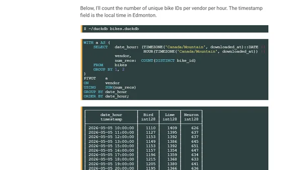
Blogs
A blog covering data visualization, spatial analysis in R, election mapping, and social science data, with a focus on technical methods and tools.
A technical analysis of NYC mayoral election results using R, spatial data, and GIS techniques to create maps visualizing precinct-level voting patterns.
A guide to methods and R implementations for comparing spatial patterns in raster data, covering continuous and categorical data for overlapping and arbitrary regions.
A technical guide comparing spatial patterns in categorical raster data using R, focusing on landscape metrics and code examples.
A technical guide comparing spatial patterns in categorical raster data using R, focusing on land cover change analysis.
A technical guide on comparing spatial patterns in continuous raster data using R, focusing on methods for arbitrary regions.
A technical guide comparing spatial patterns in continuous raster data for overlapping regions using R, focusing on NDVI data analysis.
A technical guide to methods for comparing spatial patterns in raster data, focusing on analysis using R for both continuous and categorical data.
Explains how to extract and analyze spatial patterns from categorical raster data using the 'motif' R package and information theory metrics.
A technical benchmark comparing PostgreSQL, ClickHouse, and BigQuery for fast geospatial coordinate conversion using Uber's H3 hexagon system.
Final blog post in a series on the 'motif' R package, summarizing pattern-based spatial analysis methods and future research directions.
A technical guide on using R and spatial analysis to quantify changes in land cover patterns in the Amazon between 1992 and 2018.
A technical tutorial on using R and geospatial analysis to find areas with similar topography to a query region, focusing on spatial pattern matching.
Explains spatial signatures and co-occurrence matrices for analyzing patterns in categorical raster data like land cover.
An introduction to pattern-based spatial analysis in R using the 'motif' package for analyzing categorical raster data like land cover maps.
A technical guide on using the R 'raceland' package to analyze and visualize racial diversity and segregation using spatial data and information theory metrics.
Explains how information theory and R code can quantify and classify spatial patterns, with examples from landscape ecology.
A technical guide on calculating landscape metrics in R using spatial data and buffers around sampling points for ecological analysis.
Explains how to use GeoPAT 2 software to measure changes in landscape patterns over time using spatial analysis techniques.
Explains the core concepts of pattern-based spatial analysis in GeoPAT 2, including motifels, signatures, and similarity metrics.