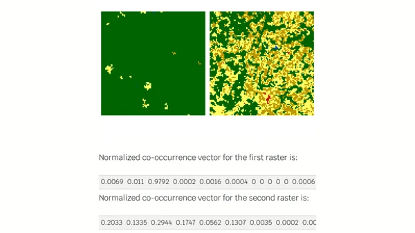
How to choose a bivariate color palette?
A guide on selecting colorblind-friendly bivariate color palettes for data visualization, with examples in R.
Jakub Nowosad is a computational geographer and Associate Professor at Adam Mickiewicz University, also serving as a Visiting Scientist at the University of Münster. He develops open-source tools and spatial methods for reproducible, scalable environmental and ecological analysis, and co-authors Geocomputation with R and Geocomputation with Python.
42 articles from this blog
A guide on selecting colorblind-friendly bivariate color palettes for data visualization, with examples in R.
A technical guide on using the R 'raceland' package to analyze and visualize racial diversity and segregation using spatial data and information theory metrics.
Analysis of R 4.0's new default color palette, testing its accessibility for color vision deficiencies using the colorblindcheck package.
Explains how information theory and R code can quantify and classify spatial patterns, with examples from landscape ecology.
A technical tutorial on creating animated cartograms in R to visualize global population growth and distribution from 1800 to 2100.
A technical guide on calculating landscape metrics in R using spatial data and buffers around sampling points for ecological analysis.
A technical tutorial on using GeoPAT2 and R to calculate Shannon entropy for land cover patterns in local landscapes.
Announcing the completion of the open-source book 'Geocomputation with R', detailing its collaborative creation, purpose, and availability.
A tutorial on using R to reproduce and analyze map projection distortions, focusing on the Web Mercator projection with reproducible code.
A tutorial on creating an animated world population cartogram from 1800 to 2100 using R, open data, and open-source geospatial libraries.
Introduces the 'sabre' R package for quantitatively comparing two categorical maps or regionalizations to measure spatial similarity.
Final post in the GeoPAT 2 series, exploring advanced pattern-based spatial analysis methods and integration into custom workflows.
Explains pattern-based regionalization using GeoPAT 2 software to segment landscapes into homogeneous regions based on spatial patterns.
Explains how to use GeoPAT 2 software to measure changes in landscape patterns over time using spatial analysis techniques.
A technical tutorial on using GeoPAT 2 software to find geographically similar landscapes through pattern-based spatial analysis.
Explains the core concepts of pattern-based spatial analysis in GeoPAT 2, including motifels, signatures, and similarity metrics.
A tutorial on using R packages to download, process, and visualize global life expectancy data from the World Bank API.
Introduces GeoPAT 2, an open-source software for pattern-based spatial and temporal analysis of categorical maps like land cover.
A technical tutorial on creating US maps with R, including Alaska and Hawaii as properly scaled insets using the sf and tmap packages.
An update on the 'Geocomputation with R' book, covering progress on chapters about spatial data, analysis, and future plans for advanced methods.