Natural Earth's Global Geospatial Datasets
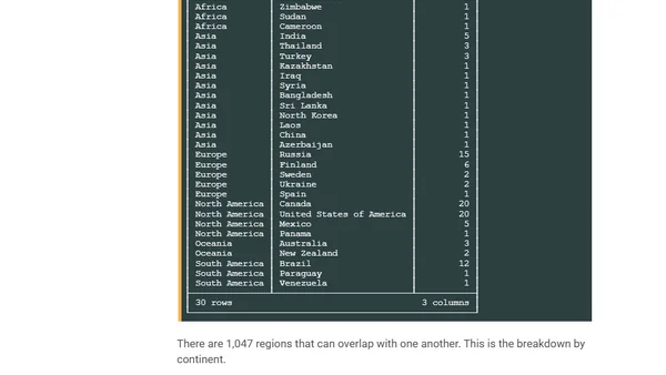
Read OriginalThis article provides a detailed, technical walkthrough for working with Natural Earth's free global geospatial datasets. It covers installing prerequisites (AWS CLI, DuckDB with spatial extensions), downloading the vector and raster datasets from S3, and using QGIS for map rendering. The content is focused on the technical process of handling geospatial data, which falls under data processing and IT tools.
Comments
No comments yet
Be the first to share your thoughts!
Browser Extension
Get instant access to AllDevBlogs from your browser
Top of the Week
1
Limit token usage in Microsoft Agent Framework
Jesse Liberty
•
1 votes
2
How to Roll Back AI Agents: Incident Response, Circuit Breakers, and Recovery Patterns
Paul Bryant
•
1 votes
3
Avoiding Reasoning Model Failures with Microsoft Foundry
Luke Murray
•
1 votes
4
When Your AI Agent Lies: Silent LLM Fallbacks
Luke Murray
•
1 votes
5
Adding a custom MCP server to Claude and ChatGPT
Simon Willison
•
1 votes
6
Testing AI prompts and comparing models with promptfoo
Tim Deschryver
•
1 votes
7
Superlogical
Mitchell Hashimoto
•
1 votes